| dc.contributor.author | Cadastral & Land Surveys Ltd. | |
| dc.coverage.spatial | Cobb County (Ga.) | |
| dc.date.accessioned | 2021-10-22T15:42:43Z | |
| dc.date.created | 5/8/1981 | |
| dc.date.issued | 2021-10-22T15:42:43Z | |
| dc.date.issued | 2021-10-22T15:42:43Z | |
| dc.date.issued | 2021-10-22T15:42:43Z | |
| dc.identifier | 8058-C1 | |
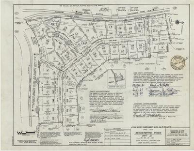
| dc.identifier.citation | Final Plat for Wetherbyrne Woods, Unit II, 1981, Douglas D. Middleton survey maps, 1970-1992, SC/M/008, Kennesaw State University Archives. | |
| dc.identifier.uri | https://soar.kennesaw.edu/handle/11360/6570 | |
| dc.description | Final plat for Wetherburne Woods, Unit II created on May 8, 1981, with the latest revisions carried out on June 1, 1981. The units are located in land lots 97, 98, 131, and 132, 20th district, Cobb County. | |
| dc.description.abstract | Final plat of land lots 97, 98, 131, and 132 of the 20th District, 2nd Section, Cobb County, Georgia | |
| dc.format.mimetype | image/jpeg | |
| dc.language.iso | en_US | |
| dc.relation.ispartof | http://archivesspace.kennesaw.edu/repositories/4/resources/434 | |
| dc.rights | Kennesaw State University's Department of Museums, Archives & Rare Books provides the information contained on this site for non-commercial, personal, or research use only. All other use, including but not limited to commercial or scholarly reproductions, redistribution, publication or transmission, whether by electronic means or otherwise, without prior written permission of the copyright holder is strictly prohibited. | |
| dc.subject | Cobb County (Ga.)--Surveys | |
| dc.subject | Surveying | |
| dc.subject | Land subdivision | |
| dc.subject | Real property--Maps | |
| dc.title | Final Plat for Wetherbyrne Woods, Unit II | |
| dc.type | image | |

